

The rgee package provides an R interface to Google Earth Engine (GEE), allowing spatial data analysis on GEE’s cloud platform using familiar R syntax and the pipe operator. It supports the full Earth Engine class hierarchy—images, image collections, features, feature collections, and geometries—along with data import/export, visualization, and GEE asset management.
What’s covered#
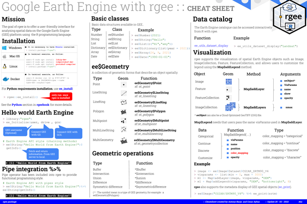
- Mission and installation – setup for Windows, macOS, Linux, and Docker with
ee_install() - Basic classes –
ee$Number,ee$String,ee$Date,ee$Array,ee$Dictionary,ee$List - Geometric types –
ee$Geometry$Point,Polygon,MultiLineString,MultiGeometry, and sf equivalents - Geometric operations –
$buffer(),$intersection(),$union(),$difference(),$symmetricdifference() - Data catalog –
ee_utils_dataset_display()for searching Earth Engine datasets - Visualization –
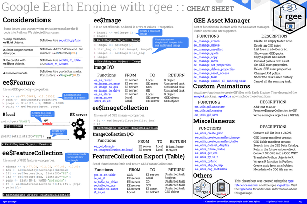
Map$addLayer(),Map$addLegend(),ee_print()for metadata display - Image and ImageCollection I/O –
ee_as_raster(),ee_as_stars(),ee_image_to_drive(),raster_as_ee() - GEE Asset Manager –
ee_manage_create(),ee_manage_delete(),ee_manage_copy(), and related functions - Custom animations –
ee_utils_gif_creator(),ee_utils_gif_annotate(),ee_utils_gif_save()